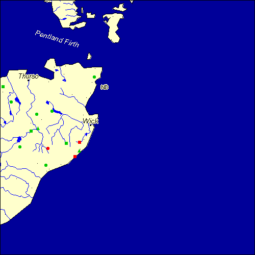
Stone Circles and Rows on Map Sheet ND
| HY |
||
| NC |
| |
| NJ |

Move the mouse over a point on the map to see the Stone Circle's name and map reference in the status bar.
| HY |
||
| NC |
| |
| NJ |
Move the mouse over a point on the map to see the Stone Circle's name and map reference in the status bar.
The Map sheet ND covers a 100 km2 area which includes the following stone circles and rows:
Achanarras Hill Stone Circle at map reference ND145552. Achavanich Stone Circle at map reference ND188417. www Aultan Broubster Stone Circle at map reference ND045599. Backlass Stone Circle at map reference ND079423. Broughwin group at map reference ND311409. Camster Stone Row(s) at map reference ND260437. Dirlot Stone Row(s) at map reference ND123485. Guidebest Stone Circle at map reference ND181351. Hill O` Many Stanes Stone Row(s) at map reference ND295384. www Loch Of Yarrows Stone Row(s) at map reference ND313440. www Old Hall Of Dunn Stone Circle at map reference ND204564. Tormsdale group at map reference ND148497. Upper Dounreay I Stone Row(s) at map reference ND012660. Warth Hill Stone Circle at map reference ND371698. Map sheet ND is also the likely location for the following stone circles and rows which have been destroyed: - Upper Dounreay II Stone Row(s) at approximate map reference ND007660. - Shurrery Stone Circle at approximate map reference ND040570. - Acherole Stone Circle at approximate map reference ND220510. These lost megalithic sites do not appear on the map above, as their locations are uncertain. Any information about these sites, particularly if you know they exist, would be very much appreciated.
Mail us with any information. The name and map reference of the megaliths appear in the status bar when the mouse pointer is placed over a point on the map above. In each map reference, the letters ND refer to the 100 km2 sheet shown above. The next three numbers are the distance across from the left edge (0 to 999)
and the final three numbers are the distance up from the bottom edge, (0 to 999). A point on the map in red has further details on another web site, a point in green does not Circles on the map represent stone circles, squares represent single or multiple stone rows or avenues, triangles represent group sites
with two or more megalithic sites close together.
 |
The list of stone circles and rows included in this resource is now available for browsing alphabetically. |
 |
Any stone circle or row indicated on the above map has further details given on a separate page here at the Megalith Map. Circles and rows indicated by a www tag, have links to websites elsewhere on the internet containing more text and/or images. Tell us about a stone circle or row not included on the above map by dropping us a line, and helping us to make this resource better for all who use it.
Go back to the map of the British Isles.
This information is brought to you by Andy and Alastair's Cheeseless ProductionsTM. This page published on 03/10/98 22:04:02.