Stone Circles and Rows on Map Sheet NH
| NC |
||
| NG |
| NJ |
| NN |

Move the mouse over a point on the map to see the Stone Circle's name and map reference in the status bar.
| NC |
||
| NG |
| NJ |
| NN |
Move the mouse over a point on the map to see the Stone Circle's name and map reference in the status bar.
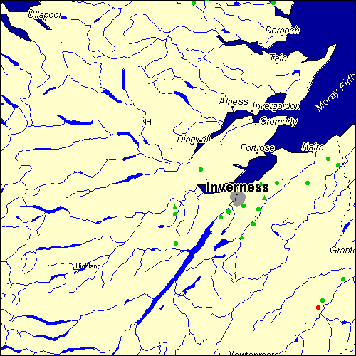
The Map sheet NH covers a 100 km2 area which includes the following stone circles and rows:
Aberscross Stone Circle at map reference NH770991. Auldearn Stone Circle at map reference NH924553. Aviemore Stone Circle at map reference NH896134. www Boblainy Stone Circle at map reference NH493396. Carn Daley Stone Circle at map reference NH494314. Carn Urnan Stone Circle at map reference NH566523. Culburnie group at map reference NH491418. Dalcross Mains Stone Circle at map reference NH779484. Daviot Stone Circle at map reference NH727411. Druidtemple Stone Circle at map reference NH685420. Grenish Stone Circle at map reference NH907154. Kinchyle Of Dores Stone Circle at map reference NH621389. Leanach group at map reference NH743444. Linsidemore Stone Circle at map reference NH545992. Little Urchany Stone Circle at map reference NH866485. Midlairgs Stone Circle at map reference NH714368. Moyness Stone Circle at map reference NH952536. Newton Of Petty group at map reference NH734485. Torbreck Stone Circle at map reference NH644404. Tordarroch group at map reference NH679334. Tullochgorm Stone Circle at map reference NH965215. The name and map reference of the megaliths appear in the status bar when the mouse pointer is placed over a point on the map above. In each map reference, the letters NH refer to the 100 km2 sheet shown above. The next three numbers are the distance across from the left edge (0 to 999)
and the final three numbers are the distance up from the bottom edge, (0 to 999). A point on the map in red has further details on another web site, a point in green does not Circles on the map represent stone circles, squares represent single or multiple stone rows or avenues, triangles represent group sites
with two or more megalithic sites close together.
 |
The list of stone circles and rows included in this resource is now available for browsing alphabetically. |
 |
Any stone circle or row indicated on the above map has further details given on a separate page here at the Megalith Map. Circles and rows indicated by a www tag, have links to websites elsewhere on the internet containing more text and/or images. Tell us about a stone circle or row not included on the above map by dropping us a line, and helping us to make this resource better for all who use it.
Go back to the map of the British Isles.
This information is brought to you by Andy and Alastair's Cheeseless ProductionsTM. This page published on 03/10/98 22:04:29.