Stone Circles and Rows on Map Sheet NR
| NM |
||
| NS |
|

Move the mouse over a point on the map to see the Stone Circle's name and map reference in the status bar.
| NM |
||
|
| NS |
|
Move the mouse over a point on the map to see the Stone Circle's name and map reference in the status bar.
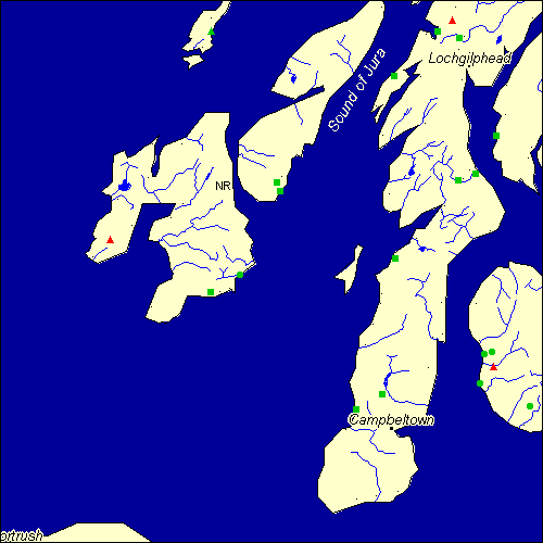
The Map sheet NR covers a 100 km2 area which includes the following stone circles and rows:
Achnacarran Stone Row(s) at map reference NR389460. Ardilistry Stone Circle at map reference NR442493. Auchagallon Stone Circle at map reference NR893346. Aucheleffan Stone Circle at map reference NR978251. Ballochroy Stone Row(s) at map reference NR730524. Ballymeanoch group at map reference NR833964. www Carragh a`Ghlinne Stone Row(s) at map reference NR512664. Clochkeil Stone Row(s) at map reference NR657244. Crinan Moss Stone Row(s) at map reference NR808941. Drumidoon Stone Circle at map reference NR886292. Dunamuck North Stone Row(s) at map reference NR847929. Escart Stone Row(s) at map reference NR846667. Inveryne Stone Row(s) at map reference NR915749. Lossit Burn group at map reference NR202560. www Machrie Burn Stone Circle at map reference NR908351. Machrie Moor group at map reference NR910325. www Mealdarroch Stone Row(s) at map reference NR877680. Sannaig Stone Row(s) at map reference NR518648. Scalasaig group at map reference NR388943. Skeroblin Stone Row(s) at map reference NR706273. Upper Fernoch Stone Row(s) at map reference NR727860. Map sheet NR is also the likely location for the following stone circles and rows which have been destroyed: - Macrihanish Stone Row(s) at approximate map reference NR644206. These lost megalithic sites do not appear on the map above, as their locations are uncertain. Any information about these sites, particularly if you know they exist, would be very much appreciated.
Mail us with any information. The name and map reference of the megaliths appear in the status bar when the mouse pointer is placed over a point on the map above. In each map reference, the letters NR refer to the 100 km2 sheet shown above. The next three numbers are the distance across from the left edge (0 to 999)
and the final three numbers are the distance up from the bottom edge, (0 to 999). A point on the map in red has further details on another web site, a point in green does not Circles on the map represent stone circles, squares represent single or multiple stone rows or avenues, triangles represent group sites
with two or more megalithic sites close together.
 |
The list of stone circles and rows included in this resource is now available for browsing alphabetically. |
 |
Any stone circle or row indicated on the above map has further details given on a separate page here at the Megalith Map. Circles and rows indicated by a www tag, have links to websites elsewhere on the internet containing more text and/or images. Tell us about a stone circle or row not included on the above map by dropping us a line, and helping us to make this resource better for all who use it.
Go back to the map of the British Isles.
This information is brought to you by Andy and Alastair's Cheeseless ProductionsTM. This page published on 03/10/98 22:06:08.