Stone Circles and Rows on Map Sheet SD
| NY |
||
| SC |
| SE |
| SJ |

Move the mouse over a point on the map to see the Stone Circle's name and map reference in the status bar.
| NY |
||
| SC |
| SE |
| SJ |
Move the mouse over a point on the map to see the Stone Circle's name and map reference in the status bar.
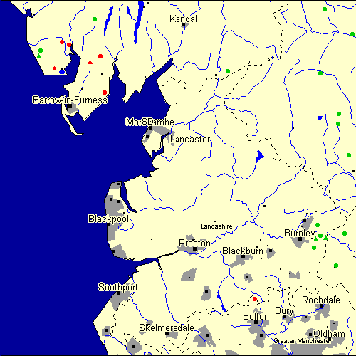
The Map sheet SD covers a 100 km2 area which includes the following stone circles and rows:
Ash-House Wood Stone Circle at map reference SD192873. www Bleaberry Haws Stone Circle at map reference SD264946. Carperby Stone Circle at map reference SD990904. Casterton Stone Circle at map reference SD640799. Cheetham Close Stone Circle at map reference SD716159. www Druids Altar Stone Circle at map reference SD949652. Druids Temple Stone Circle at map reference SD292739. www Extwistle Moor Stone Circle at map reference SD900337. Hall Foss Stone Circle at map reference SD112857. Hellclough group at map reference SD914333. Kilnsey Stone Circle at map reference SD951680. Kirkstones group at map reference SD106843. Lacra group at map reference SD150810. www Mosley Height Stone Circle at map reference SD881302. Muker Stone Circle at map reference SD911973. Nettlehole Ridge Stone Circle at map reference SD979563. Ring Stones Hill Stone Circle at map reference SD892367. Swinside Stone Circle at map reference SD172882. www The Beacon Stone Circle at map reference SD280842. www The Kirk group at map reference SD251827. www Todmorden Stone Circle at map reference SD943253. Walshaw Dean Reservoir Stone Circle at map reference SD967342. Worsthorne group at map reference SD885329. Yockenthwaite Stone Circle at map reference SD899794. Map sheet SD is also the likely location for the following stone circles and rows which have been destroyed: - Cleatop Park Stone Circle at approximate map reference SD821613. Apparently, the circle was destroyed by the farmer of the land in the1870s. I recently visited the site, but there is little to see apart
from a few shapeless hollows.
The original documentary reference to the Cleatop Park circle
is to be found in Thomas Brayshaw's History of the Ancient Parish of
Giggleswick (p.8; 1932), and I have included the full reference below
for your files:
"The Ordnance Map marks, on the steep slope to the north of Cleatop
Wood, 'site of Stone Circle'. It needs a very keen eye to identify the
few stumps that remain today, and it is deplorable that this most
interesting monument, after enduring for so many centuries, has been
destroyed during the last eighty years. In 1847 a description of the
circle, as it then was, was sent to Capt.Yolland of the Ordnance Survey.
"I suppose", said the writer, "the circle of stones in Cleatop High Park
to be aboriginal British or Druidical remains from the following
appearances :- the circle is complete and the large stones are set on
end, some of them several tons weight. The stones are twelve in number
now standing, beside several others that seem to be rolled a short
distance, as it is placed on the ascent of a steep hill and commands a
beautiful and extensive prospect (more so than any given point of the
same altitude in the vicinity). The circle is 36 feet in diameter."
A few stones were still standing in 1883. The hill above long bore the
name Druids Hill. The Enclosure Acts passed towards the end of the 18th
century greatly increased the number of drystone walls in the parish,
and it is probable that many old stone monuments were destroyed in
making them and in their subsequent repair".
In another reference that I can't lay my hands on at the minute, it
mentions that the circle was originally so complete and regular in shape
that it could be made out on the hillside from quite a distance, and
that it was glaringly obvious when a stone was removed. Anyway, it's
gone now, but the views from the site are still impressive.
Nick Harling.
- Rawthey Bridge Stone Circle at approximate map reference SD710970. These lost megalithic sites do not appear on the map above, as their locations are uncertain. Any information about these sites, particularly if you know they exist, would be very much appreciated.
Mail us with any information. The name and map reference of the megaliths appear in the status bar when the mouse pointer is placed over a point on the map above. In each map reference, the letters SD refer to the 100 km2 sheet shown above. The next three numbers are the distance across from the left edge (0 to 999)
and the final three numbers are the distance up from the bottom edge, (0 to 999). A point on the map in red has further details on another web site, a point in green does not Circles on the map represent stone circles, squares represent single or multiple stone rows or avenues, triangles represent group sites
with two or more megalithic sites close together.
 |
The list of stone circles and rows included in this resource is now available for browsing alphabetically. |
 |
Any stone circle or row indicated on the above map has further details given on a separate page here at the Megalith Map. Circles and rows indicated by a www tag, have links to websites elsewhere on the internet containing more text and/or images. Tell us about a stone circle or row not included on the above map by dropping us a line, and helping us to make this resource better for all who use it.
Go back to the map of the British Isles.
This information is brought to you by Andy and Alastair's Cheeseless ProductionsTM. This page published on 03/10/98 22:07:27.