Stone Circles and Rows on Map Sheet W
| R |
||
| V |
| |

Move the mouse over a point on the map to see the Stone Circle's name and map reference in the status bar.
| R |
||
| V |
| |
Move the mouse over a point on the map to see the Stone Circle's name and map reference in the status bar.
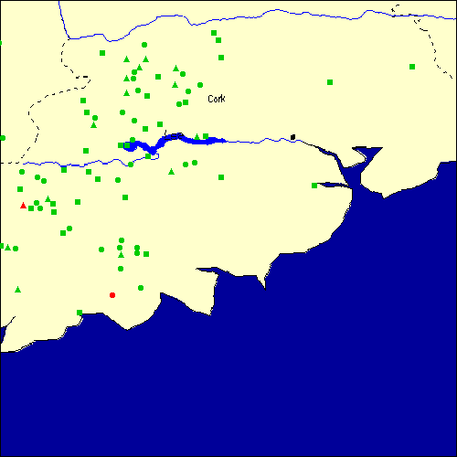
The Map sheet W covers a 100 km2 area which includes the following stone circles and rows:
Annagannihy group at map reference W385851. Ardrah Stone Row(s) at map reference W069544. Ballindeenisk Stone Row(s) at map reference W723819. Bealick Stone Row(s) at map reference W351727. Beenalaght Stone Row(s) at map reference W485873. Behagullane Stone Row(s) at map reference W275567. Bellmount Lower Stone Circle at map reference W427643. Bohonagh Stone Circle at map reference W308368. Breeney More group at map reference W050552. www Cappaboy Beg Stone Circle at map reference W082612. Cappaboy Beg SE Stone Circle at map reference W097604. Carriganimmy Stone Circle at map reference W293827. Carrigaphooca Stone Circle at map reference W294735. Carrigonirtane group at map reference W276797. Castlenalacht Stone Row(s) at map reference W485612. Clodagh Stone Circle at map reference W152499. Cloghboola Beg group at map reference W305853. Cloghboola More group at map reference W277872. Cloonshear Beg Stone Row(s) at map reference W264682. Coolacoosane Stone Row(s) at map reference W323789. Coolavoher Stone Row(s) at map reference W191753. Coolclevane Stone Circle at map reference W287639. Coolgarriff Stone Row(s) at map reference W407776. Coomleagh East Stone Row(s) at map reference W119536. Cullenagh Stone Row(s) at map reference W116553. Cullomane E Stone Circle at map reference W035455. Cullomane group at map reference W017459. Currebeha Stone Circle at map reference W407640. Derrynafinchin Stone Circle at map reference W048623. Derrynagree Stone Row(s) at map reference W140627. Derrynasaggart Stone Row(s) at map reference W183780. Dooneens group at map reference W382815. Drombeg Stone Circle at map reference W247352. www Dromcarra N Stone Row(s) at map reference W278681. Dromdrasil Stone Row(s) at map reference W171557. Durraghalicky Stone Circle at map reference W223453. Farrannahineeny Stone Row(s) at map reference W214607. Garrane Stone Row(s) at map reference W478912. Garryduff Stone Row(s) at map reference W904854. Glantane group at map reference W277830. Glenleigh Stone Circle at map reference W316901. Gneeves Stone Row(s) at map reference W469928. Gortanimill Stone Circle at map reference W208741. Gortnacowly Stone Circle at map reference W088543. Gortroe Stone Circle at map reference W259605. Gortyleahy Stone Row(s) at map reference W319717. Gurranes Stone Row(s) at map reference W175315. Gurteen Stone Circle at map reference W006698. Kippagh Stone Row(s) at map reference W225883. Knockagappul Stone Row(s) at map reference W346831. Knockaneirk group at map reference W374625. Knockatlowig Stone Row(s) at map reference W320443. Knockavullig group at map reference W430701. Knocknakilla Stone Circle at map reference W294842. Knockraheen Stone Circle at map reference W303802. Knocks A Stone Circle at map reference W300445. Knocks B Stone Circle at map reference W300456. Laharankeel Stone Circle at map reference W393772. Leitry Lower Stone Row(s) at map reference W138488. Lettergorman Stone Circle at map reference W267473. Lettergorman SW Stone Circle at map reference W263457. Lissaclarig group at map reference W039367. Lissacresig Stone Circle at map reference W269754. Loughatooma N Stone Circle at map reference W401838. Maughanasilly I Stone Row(s) at map reference W044585. Maughanclea B Stone Circle at map reference W080556. Maughanclea group at map reference W104565. Maunatanvally group at map reference W264442. Monavaddra Stone Row(s) at map reference W195623. Oughtihery SE Stone Circle at map reference W413799. Piercetown Stone Row(s) at map reference W690593. Reanascreena Stone Circle at map reference W265410. Reanerre group at map reference W204727. Roovesmore Stone Row(s) at map reference W450702. Rossnakilla Stone Row(s) at map reference W324658. Rylane Stone Circle at map reference W438813. Scartbaun Stone Row(s) at map reference W003461. Teergay Stone Circle at map reference W291694. Templebryan Stone Circle at map reference W386438. www Tullig group at map reference W318872. Turnaspidogy Stone Row(s) at map reference W188670. Map sheet W is also the likely location for the following stone circles and rows which have been destroyed: - Kippagh Stone Circle at approximate map reference W240470. - Bellmount Upper Stone Circle at approximate map reference W430640. - Clonleigh Stone Circle at approximate map reference W670490. - Coolmountain Stone Circle at approximate map reference W190600. - Curraghroe Stone Circle at approximate map reference W770860. - Glancarney Stone Circle at approximate map reference W140560. - Gowlane N Stone Circle at approximate map reference W470860. - Ballvackey Stone Circle at approximate map reference W340420. - Kilboultragh Stone Circle at approximate map reference W330760. - Pluckanes North Stone Row(s) at approximate map reference W536845. - Lissard Stone Circle at approximate map reference W570900. - Maulmore Stone Circle at approximate map reference W300800. - Reim Na Gaoithe Stone Circle at approximate map reference W560920. - Rosnascalp Stone Circle at approximate map reference W410750. - Shandagan Stone Circle at approximate map reference W410660. - Barrahaurin Stone Row(s) at approximate map reference W452824. - Grenagh S Stone Circle at approximate map reference W580840. These lost megalithic sites do not appear on the map above, as their locations are uncertain. Any information about these sites, particularly if you know they exist, would be very much appreciated.
Mail us with any information. The name and map reference of the megaliths appear in the status bar when the mouse pointer is placed over a point on the map above. In each map reference, the letters W refer to the 100 km2 sheet shown above. The next three numbers are the distance across from the left edge (0 to 999)
and the final three numbers are the distance up from the bottom edge, (0 to 999). A point on the map in red has further details on another web site, a point in green does not Circles on the map represent stone circles, squares represent single or multiple stone rows or avenues, triangles represent group sites
with two or more megalithic sites close together.
 |
The list of stone circles and rows included in this resource is now available for browsing alphabetically. |
 |
Any stone circle or row indicated on the above map has further details given on a separate page here at the Megalith Map. Circles and rows indicated by a www tag, have links to websites elsewhere on the internet containing more text and/or images. Tell us about a stone circle or row not included on the above map by dropping us a line, and helping us to make this resource better for all who use it.
Go back to the map of the British Isles.
This information is brought to you by Andy and Alastair's Cheeseless ProductionsTM. This page published on 03/10/98 22:09:56.