Stone Circles and Rows on Map Sheet NN
| NH |
||
| NM |
| NO |
| NS |

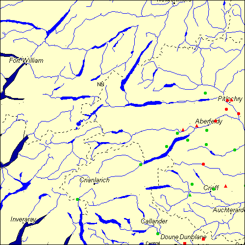
Move the mouse over a point on the map to see the Stone Circle's name and map reference in the status bar.
| NH |
||
| NM |
| NO |
| NS |
Move the mouse over a point on the map to see the Stone Circle's name and map reference in the status bar.
The Map sheet NN covers a 100 km2 area which includes the following stone circles and rows:
Airlich Stone Circle at map reference NN959386. Balmuick Stone Circle at map reference NN785247. Balnakeilly group at map reference NN946594. www Clach Na Tiompan Stone Circle at map reference NN831329. www Clachan An Diridh Stone Circle at map reference NN925553. www Coilleachur Stone Circle at map reference NN845466. Cowden group at map reference NN776205. Cramrar Stone Circle at map reference NN725455. Doune Stone Row(s) at map reference NN755005. www Faskally Cottages Stone Circle at map reference NN930589. www Ferntower Stone Circle at map reference NN874226. Fortingall group at map reference NN747470. www Greenland Stone Circle at map reference NN767427. Inverarnon Stone Circle at map reference NN316185. Kinnel Stone Circle at map reference NN576327. Lundin Farm Stone Circle at map reference NN882505. www Machuinn Stone Circle at map reference NN682401. Na Carraigean Edintean Stone Circle at map reference NN839620. Sheriff Muir Stone Row(s) at map reference NN832022. www Shian Stone Circle at map reference NN844408. Tegarmuchd group at map reference NN803486. www Thorn group at map reference NN921240. www Tigh Na Ruaich Stone Circle at map reference NN975535. www Wester Torrie Stone Circle at map reference NN646045. Map sheet NN is also the likely location for the following stone circles and rows which have been destroyed: - Craggish Stone Row(s) at approximate map reference NN763207. These lost megalithic sites do not appear on the map above, as their locations are uncertain. Any information about these sites, particularly if you know they exist, would be very much appreciated.
Mail us with any information. The name and map reference of the megaliths appear in the status bar when the mouse pointer is placed over a point on the map above. In each map reference, the letters NN refer to the 100 km2 sheet shown above. The next three numbers are the distance across from the left edge (0 to 999)
and the final three numbers are the distance up from the bottom edge, (0 to 999). A point on the map in red has further details on another web site, a point in green does not Circles on the map represent stone circles, squares represent single or multiple stone rows or avenues, triangles represent group sites
with two or more megalithic sites close together.
 |
The list of stone circles and rows included in this resource is now available for browsing alphabetically. |
 |
Any stone circle or row indicated on the above map has further details given on a separate page here at the Megalith Map. Circles and rows indicated by a www tag, have links to websites elsewhere on the internet containing more text and/or images. Tell us about a stone circle or row not included on the above map by dropping us a line, and helping us to make this resource better for all who use it.
Go back to the map of the British Isles.
This information is brought to you by Andy and Alastair's Cheeseless ProductionsTM. This page published on 03/10/98 22:05:42.