Stone Circles and Rows on Map Sheet SN
| SH |
||
| SM |
| SO |
| SS |

Move the mouse over a point on the map to see the Stone Circle's name and map reference in the status bar.
| SH |
||
| SM |
| SO |
| SS |
Move the mouse over a point on the map to see the Stone Circle's name and map reference in the status bar.
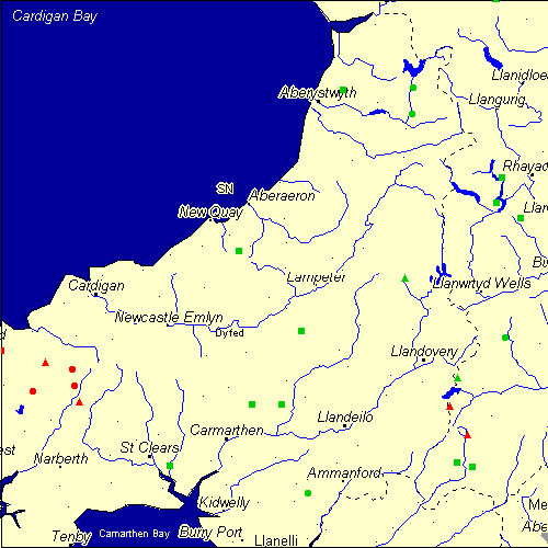
The Map sheet SN covers a 100 km2 area which includes the following stone circles and rows:
Banc Rhosgoch Fach Stone Row(s) at map reference SN435541. Bedd Arthur Stone Circle at map reference SN131324. www Cefn Gwernffrwd group at map reference SN737492. Cerrig Duon group at map reference SN851206. www Dyffryn Syfynwy Stone Circle at map reference SN059284. www Gors Fawr Stone Circle at map reference SN134294. www Hirnant Stone Circle at map reference SN753839. Llech Ciste Stone Row(s) at map reference SN514261. Meini Gwyr group at map reference SN142266. www Meini-Gwyn Stone Row(s) at map reference SN459261. Mynydd Llanbyther Stone Row(s) at map reference SN549395. Nant Tarw group at map reference SN820258. www Pen y Garreg Stone Row(s) at map reference SN915676. Plas Gogerddan Stone Row(s) at map reference SN626835. Pont Ddu Stone Row(s) at map reference SN309149. Rhos y Gelynen Stones Stone Row(s) at map reference SN906630. Saith Maen Stone Row(s) at map reference SN949602. Saith Maen NW Stone Row(s) at map reference SN833154. Saith Maen SE Stone Row(s) at map reference SN862146. Trecastle Mountain group at map reference SN833311. Troed y rhiw group at map reference SN080339. www Y Naw Carreg Stone Circle at map reference SN561099. Ynys-Hir Stone Circle at map reference SN921383. Ysbyty Cynfyn Stone Circle at map reference SN752791. Map sheet SN is also the likely location for the following stone circles and rows which have been destroyed: - Cwm y Saeson Stone Row(s) at approximate map reference SN964776. - Carreg Bicca Stone Row(s) at approximate map reference SN575305. - Cae Garreg Stone Row(s) at approximate map reference SN963777. These lost megalithic sites do not appear on the map above, as their locations are uncertain. Any information about these sites, particularly if you know they exist, would be very much appreciated.
Mail us with any information. The name and map reference of the megaliths appear in the status bar when the mouse pointer is placed over a point on the map above. In each map reference, the letters SN refer to the 100 km2 sheet shown above. The next three numbers are the distance across from the left edge (0 to 999)
and the final three numbers are the distance up from the bottom edge, (0 to 999). A point on the map in red has further details on another web site, a point in green does not Circles on the map represent stone circles, squares represent single or multiple stone rows or avenues, triangles represent group sites
with two or more megalithic sites close together.
 |
The list of stone circles and rows included in this resource is now available for browsing alphabetically. |
 |
Any stone circle or row indicated on the above map has further details given on a separate page here at the Megalith Map. Circles and rows indicated by a www tag, have links to websites elsewhere on the internet containing more text and/or images. Tell us about a stone circle or row not included on the above map by dropping us a line, and helping us to make this resource better for all who use it.
Go back to the map of the British Isles.
This information is brought to you by Andy and Alastair's Cheeseless ProductionsTM. This page published on 03/10/98 22:08:10.