Stone Circles and Rows on Map Sheet SS
| SN |
||
| ST |
|
| SX |

Move the mouse over a point on the map to see the Stone Circle's name and map reference in the status bar.
| SN |
||
|
| ST |
|
| SX |
Move the mouse over a point on the map to see the Stone Circle's name and map reference in the status bar.
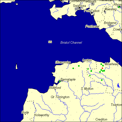
The Map sheet SS covers a 100 km2 area which includes the following stone circles and rows:
Almsworthy Stone Circle at map reference SS844417. Chains Valley Stone Row(s) at map reference SS749417. Culbone Hill Stone Row(s) at map reference SS832473. Furzehill group at map reference SS722437. Madacombe Stone Row(s) at map reference SS831425. Mattocks Down Stone Circle at map reference SS602439. Mynydd Y Gelli Stone Circle at map reference SS975942. Porlock Common NE Stone Row(s) at map reference SS846461. Porlock group at map reference SS840443. www Squallacombe Centre group at map reference SS738382. West Middleton Stone Row(s) at map reference SS648458. Wester Mill Stone Row(s) at map reference SS822409. Wilmersham Common Stone Row(s) at map reference SS856419. Withypool Stone Circle at map reference SS836343. Yelland Stone Row(s) at map reference SS490330. Map sheet SS is also the likely location for the following stone circles and rows which have been destroyed: - Wood Barrow Stone Row(s) at approximate map reference SS714423. - Mattocks Down Stone Row(s) at approximate map reference SS601438. - Long Chains Coombe NE Stone Row(s) at approximate map reference SS745423. - Lanacombe Centre E Stone Row(s) at approximate map reference SS786430. - Kittuck Stone Row(s) at approximate map reference SS820438. - Horsen Stone Row(s) at approximate map reference SS790373. - Hascombe Stone Row(s) at approximate map reference SS769383. - Codsend Moor Stone Row(s) at approximate map reference SS882411. - Clannon Ball Stone Row(s) at approximate map reference SS759436. - Brockenburrow Lane S Stone Row(s) at approximate map reference SS661423. This is an uncertain site according to Burl
These lost megalithic sites do not appear on the map above, as their locations are uncertain. Any information about these sites, particularly if you know they exist, would be very much appreciated.
Mail us with any information. The name and map reference of the megaliths appear in the status bar when the mouse pointer is placed over a point on the map above. In each map reference, the letters SS refer to the 100 km2 sheet shown above. The next three numbers are the distance across from the left edge (0 to 999)
and the final three numbers are the distance up from the bottom edge, (0 to 999). A point on the map in red has further details on another web site, a point in green does not Circles on the map represent stone circles, squares represent single or multiple stone rows or avenues, triangles represent group sites
with two or more megalithic sites close together.
 |
The list of stone circles and rows included in this resource is now available for browsing alphabetically. |
 |
Any stone circle or row indicated on the above map has further details given on a separate page here at the Megalith Map. Circles and rows indicated by a www tag, have links to websites elsewhere on the internet containing more text and/or images. Tell us about a stone circle or row not included on the above map by dropping us a line, and helping us to make this resource better for all who use it.
Go back to the map of the British Isles.
This information is brought to you by Andy and Alastair's Cheeseless ProductionsTM. This page published on 03/10/98 22:08:33.