Stone Circles and Rows on Map Sheet ST
| SO |
||
| SS |
| SU |
| SY |

Move the mouse over a point on the map to see the Stone Circle's name and map reference in the status bar.
| SO |
||
| SS |
| SU |
| SY |
Move the mouse over a point on the map to see the Stone Circle's name and map reference in the status bar.
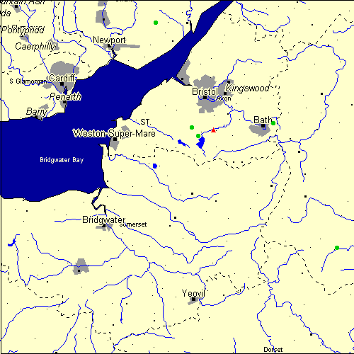
The Map sheet ST covers a 100 km2 area which includes the following stone circles and rows:
Bathampton Stone Circle at map reference ST772652. Chew Stoke Stone Circle at map reference ST560616. Grey Hill Stone Circle at map reference ST438935. Leigh Down Stone Circle at map reference ST542639. Stanton Drew group at map reference ST601634. www Tisbury Stone Circle at map reference ST951299. Map sheet ST is also the likely location for the following stone circles and rows which have been destroyed: - Twinhoe Stone Circle at approximate map reference ST730590. Twinhoe is a confusing site and many conflicting reports have been written about it. It would appear from work I've been doing, on the Skinner anuscripts (he was the first person to record the site) that it is, in fact, two cists in different locations, probably from the remains of round barrows. Wedlake excavated at what he thought was the site of the stones, but in fact excavated the revetment of a field wall!! David Mullin
These lost megalithic sites do not appear on the map above, as their locations are uncertain. Any information about these sites, particularly if you know they exist, would be very much appreciated.
Mail us with any information. The name and map reference of the megaliths appear in the status bar when the mouse pointer is placed over a point on the map above. In each map reference, the letters ST refer to the 100 km2 sheet shown above. The next three numbers are the distance across from the left edge (0 to 999)
and the final three numbers are the distance up from the bottom edge, (0 to 999). A point on the map in red has further details on another web site, a point in green does not Circles on the map represent stone circles, squares represent single or multiple stone rows or avenues, triangles represent group sites
with two or more megalithic sites close together.
 |
The list of stone circles and rows included in this resource is now available for browsing alphabetically. |
 |
Any stone circle or row indicated on the above map has further details given on a separate page here at the Megalith Map. Circles and rows indicated by a www tag, have links to websites elsewhere on the internet containing more text and/or images. Tell us about a stone circle or row not included on the above map by dropping us a line, and helping us to make this resource better for all who use it.
Go back to the map of the British Isles.
This information is brought to you by Andy and Alastair's Cheeseless ProductionsTM. This page published on 03/10/98 22:08:36.