Stone Circles and Rows on Map Sheet Q
| L |
||
| R |
|
| V |

Move the mouse over a point on the map to see the Stone Circle's name and map reference in the status bar.
| L |
||
|
| R |
|
| V |
Move the mouse over a point on the map to see the Stone Circle's name and map reference in the status bar.
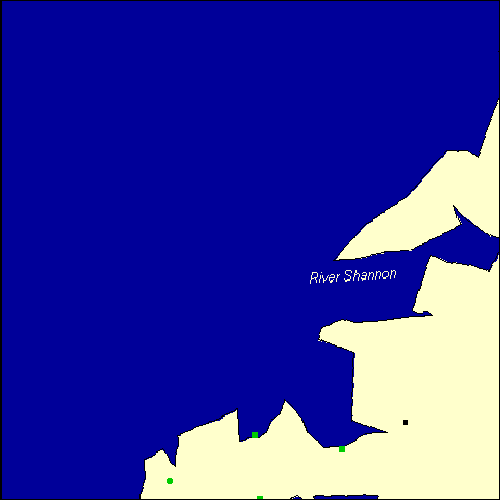
The Map sheet Q covers a 100 km2 area which includes the following stone circles and rows:
Ardamore Stone Row(s) at map reference Q521000. Ballygarret Stone Row(s) at map reference Q685101. Cloonsherragh Stone Row(s) at map reference Q511128. Teeravane Stone Circle at map reference Q340037. Map sheet Q is also the likely location for the following stone circles and rows which have been destroyed: - Curraduff Stone Row(s) at approximate map reference Q703088. - Clogher Stone Row(s) at approximate map reference Q314033. - Illaunimnal Stone Circle at approximate map reference Q600210. These lost megalithic sites do not appear on the map above, as their locations are uncertain. Any information about these sites, particularly if you know they exist, would be very much appreciated.
Mail us with any information. The name and map reference of the megaliths appear in the status bar when the mouse pointer is placed over a point on the map above. In each map reference, the letters Q refer to the 100 km2 sheet shown above. The next three numbers are the distance across from the left edge (0 to 999)
Any stone circle or row indicated on the above map has further details given on a separate page here at the Megalith Map.
Circles and rows indicated by a www tag, have links to websites elsewhere on the internet containing more text and/or images.
Tell us about a stone circle or row not included on the above map by
dropping us a line, and helping us to make this resource better for all
who use it. Go back to the map of the British Isles. This information is brought to you by Andy and Alastair's Cheeseless ProductionsTM. This page published on 03/10/98 22:07:07.