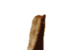
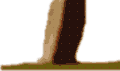
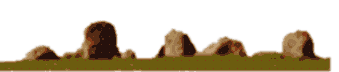
 Boleycarrigeen Stone Circle
|
Boleycarrigeen Stone Circle
|
|
|
OS Map Reference S938892.
This site is in the county of Co. Wicklow.
The nearest village is Killybeg.
The nearest town is Dunlavin.
To help get to the stones refer to OS map Discovery 62.
More details of this site can be seen at:
Follow the link to the web site where more details are available.....
Go back to map sheet S.
Browse the list of Stone Circles and Rows by name.
Go back to the map of the British Isles.
The data for these pages includes information kindly provided by Dr Aubrey Burl from the following books:
Stone Circles of the British Isles 1976,
A Guide to the Stone Circles of Britain and Ireland Yale University Press 1995,
From Carnac to Callanish : The Prehistoric Stone Rows and Avenues of Britain, Ireland and Brittany Yale University Press 1993.
Other recommended books...
The Megalith Map is brought to you by Andy and Alastair's Cheeseless ProductionsTM. This page published on 03/10/98 16:05:19.
 Virtual Fieldtrip