Stone Circles and Rows on Map Sheet SH
| SC |
||
| SJ |
|
| SN |

Move the mouse over a point on the map to see the Stone Circle's name and map reference in the status bar.
| SC |
||
|
| SJ |
|
| SN |
Move the mouse over a point on the map to see the Stone Circle's name and map reference in the status bar.
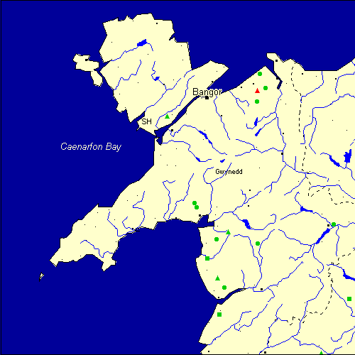
The Map sheet SH covers a 100 km2 area which includes the following stone circles and rows:
Cefn Coch Stone Circle at map reference SH548427. Cerrig Arthur Stone Circle at map reference SH631188. Cerrig Pryfaid Stone Circle at map reference SH724713. Cwn Maur Stone Circle at map reference SH553414. Druids Circle group at map reference SH723746. www Hafoty Stone Circle at map reference SH747752. Llanbedr Stone Row(s) at map reference SH583270. Llecheiddior group at map reference SH611217. Lled-Croen-Yr-Ych group at map reference SH903005. Llyn Eiddew Bach group at map reference SH642346. Moel Geodog W Stone Circle at map reference SH610324. Mynydd Dyfnant Stone Row(s) at map reference SH983156. Pabell Llywarch Hen Stone Circle at map reference SH940366. Pen-Y-Stryd Stone Circle at map reference SH725312. Red Farm Stone Circle at map reference SH732791. Tre`r Dryw Bach group at map reference SH468673. Waun Oer Stone Row(s) at map reference SH617112. Map sheet SH is also the likely location for the following stone circles and rows which have been destroyed: - Moelfre Stone Row(s) at approximate map reference SH721746. These lost megalithic sites do not appear on the map above, as their locations are uncertain. Any information about these sites, particularly if you know they exist, would be very much appreciated.
Mail us with any information. The name and map reference of the megaliths appear in the status bar when the mouse pointer is placed over a point on the map above. In each map reference, the letters SH refer to the 100 km2 sheet shown above. The next three numbers are the distance across from the left edge (0 to 999)
and the final three numbers are the distance up from the bottom edge, (0 to 999). A point on the map in red has further details on another web site, a point in green does not Circles on the map represent stone circles, squares represent single or multiple stone rows or avenues, triangles represent group sites
with two or more megalithic sites close together.
 |
The list of stone circles and rows included in this resource is now available for browsing alphabetically. |
 |
Any stone circle or row indicated on the above map has further details given on a separate page here at the Megalith Map. Circles and rows indicated by a www tag, have links to websites elsewhere on the internet containing more text and/or images. Tell us about a stone circle or row not included on the above map by dropping us a line, and helping us to make this resource better for all who use it.
Go back to the map of the British Isles.
This information is brought to you by Andy and Alastair's Cheeseless ProductionsTM. This page published on 03/10/98 22:07:47.