Stone Circles and Rows on Map Sheet SK
| SE |
||
| SJ |
| |
| SP |

Move the mouse over a point on the map to see the Stone Circle's name and map reference in the status bar.
| SE |
||
| SJ |
| |
| SP |
Move the mouse over a point on the map to see the Stone Circle's name and map reference in the status bar.
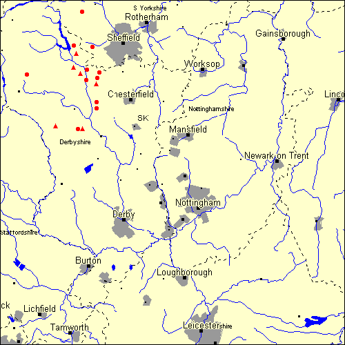
The Map sheet SK covers a 100 km2 area which includes the following stone circles and rows:
Arbor Low group at map reference SK160636. www Ash Cabin Flat Stone Circle at map reference SK269863. www Barbrook group at map reference SK278758. www Barbrook III Stone Circle at map reference SK283773. www Brown Edge Stone Circle at map reference SK288790. www Bullring Stone Circle at map reference SK078783. www Ewden Beck Stone Circle at map reference SK238966. www Eyam Moor group at map reference SK232788. www Gibbet Moor Stone Circle at map reference SK281703. www Lawrence Field Stone Circle at map reference SK253798. www Moscar Moor group at map reference SK221845. www Nine Stones Close Stone Circle at map reference SK226626. www Offerton Moor group at map reference SK213805. www Park Gate Stone Circle at map reference SK281685. www Seven Stones Of Hordron Stone Circle at map reference SK215868. www Stanton Moor group at map reference SK238628. www Stoke Flat Stone Circle at map reference SK250768. www Map sheet SK is also the likely location for the following stone circles and rows which have been destroyed: - Tunstead Stone Circle at approximate map reference SK026792. - Top Of Riley Stone Circle at approximate map reference SK226768. - Brassington Moor Stone Circle at approximate map reference SK230540. - Abney Moor Stone Circle at approximate map reference SK180790. - Seven Brideron Stone Circle at approximate map reference SK309639. Once quite large but now destroyed. A watercolour of this circle from 1784 can be seen at: http://www.geocities.com/athens/parthenon/6197/bridetop.htm
These lost megalithic sites do not appear on the map above, as their locations are uncertain. Any information about these sites, particularly if you know they exist, would be very much appreciated.
Mail us with any information. The name and map reference of the megaliths appear in the status bar when the mouse pointer is placed over a point on the map above. In each map reference, the letters SK refer to the 100 km2 sheet shown above. The next three numbers are the distance across from the left edge (0 to 999)
and the final three numbers are the distance up from the bottom edge, (0 to 999). A point on the map in red has further details on another web site, a point in green does not Circles on the map represent stone circles, squares represent single or multiple stone rows or avenues, triangles represent group sites
with two or more megalithic sites close together.
 |
The list of stone circles and rows included in this resource is now available for browsing alphabetically. |
 |
Any stone circle or row indicated on the above map has further details given on a separate page here at the Megalith Map. Circles and rows indicated by a www tag, have links to websites elsewhere on the internet containing more text and/or images. Tell us about a stone circle or row not included on the above map by dropping us a line, and helping us to make this resource better for all who use it.
Go back to the map of the British Isles.
This information is brought to you by Andy and Alastair's Cheeseless ProductionsTM. This page published on 03/10/98 22:07:55.