Stone Circles and Rows on Map Sheet C
| D |
|
| H |

Move the mouse over a point on the map to see the Stone Circle's name and map reference in the status bar.
|
| D |
|
| H |
Move the mouse over a point on the map to see the Stone Circle's name and map reference in the status bar.
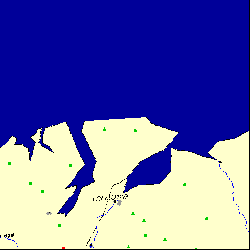
The Map sheet C covers a 100 km2 area which includes the following stone circles and rows:
Altaghoney group at map reference C515013. Aughlish group at map reference C662043. Ballygroll group at map reference C533146. Ballyholly group at map reference C577118. Barnes Lower Stone Row(s) at map reference C122263. Beltany Stone Circle at map reference C255005. www Bocan Stone Circle at map reference C544475. Clagan Stone Row(s) at map reference C583054. Coolnasillagh group at map reference C785003. Cuilbane Stone Circle at map reference C830122. Gortcorbies Stone Circle at map reference C741259. Killycolman Stone Row(s) at map reference C282334. Knocknafaugher Stone Row(s) at map reference C039344. Labbadish Stone Row(s) at map reference C238096. Portleon Stone Row(s) at map reference C172233. Rashenny group at map reference C418482. Map sheet C is also the likely location for the following stone circles and rows which have been destroyed: - Carlan Upper Stone Row(s) at approximate map reference C100300. - Slievenagh Stone Circle at approximate map reference C990020. - Magheramore Stone Circle at approximate map reference C690040. - Lackagh Stone Circle at approximate map reference C470080. - Ervey Stone Circle at approximate map reference C520120. - Carbalintober Stone Circle at approximate map reference C830110. - Ballyholly Stone Circle at approximate map reference C577118. - Aughlish Stone Circle at approximate map reference C640040. These lost megalithic sites do not appear on the map above, as their locations are uncertain. Any information about these sites, particularly if you know they exist, would be very much appreciated.
Mail us with any information. The name and map reference of the megaliths appear in the status bar when the mouse pointer is placed over a point on the map above. In each map reference, the letters C refer to the 100 km2 sheet shown above. The next three numbers are the distance across from the left edge (0 to 999)
and the final three numbers are the distance up from the bottom edge, (0 to 999). A point on the map in red has further details on another web site, a point in green does not Circles on the map represent stone circles, squares represent single or multiple stone rows or avenues, triangles represent group sites
with two or more megalithic sites close together.
 |
The list of stone circles and rows included in this resource is now available for browsing alphabetically. |
 |
Any stone circle or row indicated on the above map has further details given on a separate page here at the Megalith Map. Circles and rows indicated by a www tag, have links to websites elsewhere on the internet containing more text and/or images. Tell us about a stone circle or row not included on the above map by dropping us a line, and helping us to make this resource better for all who use it.
Go back to the map of the British Isles.
This information is brought to you by Andy and Alastair's Cheeseless ProductionsTM. This page published on 03/10/98 22:02:04.