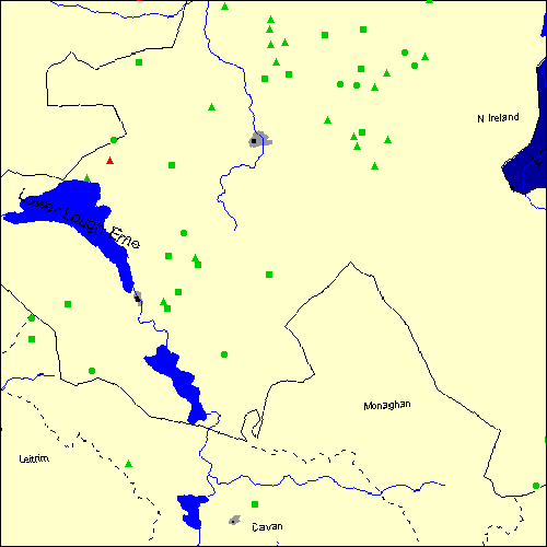
Stone Circles and Rows on Map Sheet H
C |
||
G |

| J |
N |

Move the mouse over a point on the map to see the Stone Circle's name and map reference in the status bar.
C |
||
G |

| J |
N |

Move the mouse over a point on the map to see the Stone Circle's name and map reference in the status bar.
The Map sheet H covers a 100 km2 area which includes the following stone circles and rows:
Aghalane group at map reference H495920. Aghtirourke Stone Circle at map reference H169320. Ballybriest Stone Circle at map reference H760880. Beaghmore group at map reference H685842. Broughderg Stone Circle at map reference H653843. Broughderg North Stone Row(s) at map reference H661873. Brougher group at map reference H356529. Castledamph group at map reference H522923. Castlemervyn Stone Circle at map reference H336573. Cavancarragh Stone Row(s) at map reference H306435. Cavancarragh group at map reference H299449. Cloghastuckane Stone Circle at map reference H059416. Clogherney group at map reference H493947. Clogherny Butterlope Stone Row(s) at map reference H493497. Copney group at map reference H599782. Corick group at map reference H778897. Cornamaddy group at map reference H685698. Creevy Upper Stone Row(s) at map reference H255885. Cregganconroe group at map reference H648752. Cregganconroe NE Stone Row(s) at map reference H663758. Culvacullion group at map reference H505888. Davagh Lower group at map reference H707867. Derryallen Stone Row(s) at map reference H309531. Dooish Stone Row(s) at map reference H314697. Doorat group at map reference H495966. Drumacken Stone Row(s) at map reference H362515. Drumskinny group at map reference H201707. www Dun Ruadh Stone Circle at map reference H624845. Dunbunrawer Stone Row(s) at map reference H485855. Eshbralley Stone Circle at map reference H410350. Formil group at map reference H159676. Glassmullagh group at map reference H387805. Glenmacoffer Stone Row(s) at map reference H529863. Golan Stone Row(s) at map reference H665945. Kilnavert group at map reference H235152. Knocknohorna group at map reference H410989. Moymore group at map reference H710745. Oughtboy Stone Row(s) at map reference H595935. Owenreagh Stone Circle at map reference H742903. Ratoran Stone Row(s) at map reference H326465. Reyfad Stones Stone Row(s) at map reference H124442. Scraghy Stone Circle at map reference H208743. Shantemon Stone Row(s) at map reference H466077. Shortstone East Stone Circle at map reference H982110. St Brigid` Stones Stone Row(s) at map reference H059378. Tremoge group at map reference H654733. Map sheet H is also the likely location for the following stone circles and rows which have been destroyed: - Kiltober Stone Circle at approximate map reference H430200. - Ballybrolly Stone Circle at approximate map reference H840460. - Butterlope Stone Circle at approximate map reference H490940. - Cloghbrack Stone Circle at approximate map reference H080400. - Corraderrybrock Stone Circle at approximate map reference H030420. - Creggandevesky Stone Circle at approximate map reference H630730. - Crom Cruaich Stone Circle at approximate map reference H250150. - Dooish Stone Circle at approximate map reference H310690. - Druids Temple Stone Circle at approximate map reference H430190. There is also a circle called Druids Temple on map sheet SD in England
- Dunbunrawer Stone Circle at approximate map reference H480840. - Glengeen Stone Circle at approximate map reference H370560. - Golan Stone Circle at approximate map reference H440810. - Greenan Stone Circle at approximate map reference H190350. - Aghascrebagh Stone Circle at approximate map reference H610840. - Kiltierney Stone Circle at approximate map reference H216625. - Glengeen Stone Row(s) at approximate map reference H383555. - Letteran Stone Circle at approximate map reference H810860. - Lissanover Stone Circle at approximate map reference H220150. - Loughmacrory Stone Circle at approximate map reference H580770. - Meendamph Stone Circle at approximate map reference H460970. - Mullanmore Stone Circle at approximate map reference H590750. - Oughtboy Stone Circle at approximate map reference H590930. - Ratoran Stone Circle at approximate map reference H330460. - Sheemuldoon Stone Circle at approximate map reference H250620. - Tromogagh Stone Circle at approximate map reference H110340. - Turnabarson Stone Circle at approximate map reference H680690. - Vicar`s Cairn Stone Circle at approximate map reference H910390. - Cantytrindle Stone Row(s) at approximate map reference H225555. - Edenakill Stone Row(s) at approximate map reference H978123. - Killee Stone Circle at approximate map reference H310460. These lost megalithic sites do not appear on the map above, as their locations are uncertain. Any information about these sites, particularly if you know they exist, would be very much appreciated.
Mail us with any information. The name and map reference of the megaliths appear in the status bar when the mouse pointer is placed over a point on the map above. In each map reference, the letters H refer to the 100 km2 sheet shown above. The next three numbers are the distance across from the left edge (0 to 999)
and the final three numbers are the distance up from the bottom edge, (0 to 999). A point on the map in red has further details on another web site, a point in green does not Circles on the map represent stone circles, squares represent single or multiple stone rows or avenues, triangles represent group sites
with two or more megalithic sites close together.
 |
The list of stone circles and rows included in this resource is now available for browsing alphabetically. |
 |
Any stone circle or row indicated on the above map has further details given on a separate page here at the Megalith Map. Circles and rows indicated by a www tag, have links to websites elsewhere on the internet containing more text and/or images. Tell us about a stone circle or row not included on the above map by dropping us a line, and helping us to make this resource better for all who use it.
Go back to the map of the British Isles.
This information is brought to you by Andy and Alastair's Cheeseless ProductionsTM. This page published on 03/10/98 22:02:27.