Stone Circles and Rows on Map Sheet NT
| NO |
||
| NS |
| NU |
| NY |

Move the mouse over a point on the map to see the Stone Circle's name and map reference in the status bar.
| NO |
||
| NS |
| NU |
| NY |
Move the mouse over a point on the map to see the Stone Circle's name and map reference in the status bar.
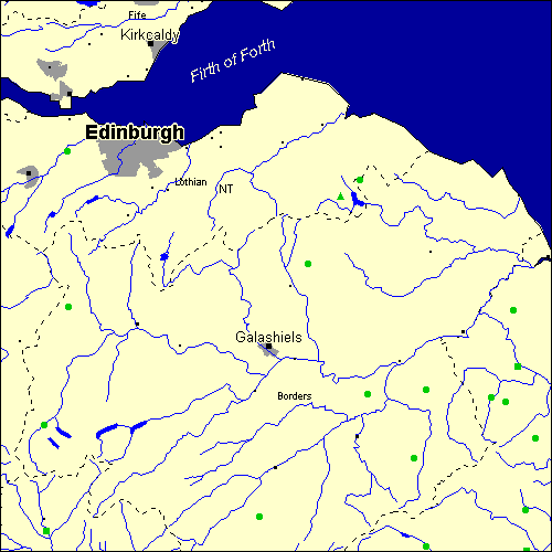
The Map sheet NT covers a 100 km2 area which includes the following stone circles and rows:
Biddlestone Stone Circle at map reference NT954074. Borrowston Rigg Stone Circle at map reference NT560521. Burgh Hill Stone Circle at map reference NT470062. Duddo Five Stones Stone Circle at map reference NT931437. Dyke Stone Row(s) at map reference NT084036. Fairnington Stone Circle at map reference NT667285. Five Kings Stone Row(s) at map reference NT955001. Five Stanes Stone Circle at map reference NT752168. Frogden Stone Circle at map reference NT774292. Harestanes Stone Circle at map reference NT124443. Hethpool Stone Circle at map reference NT892278. Ilderton Stone Circle at map reference NT971205. Mayshiel group at map reference NT617646. MilfieldHenge Stone Row(s) at map reference NT939335. Nether Dod Stone Circle at map reference NT080228. Newbridge Stone Circle at map reference NT123726. Three Kings Stone Circle at map reference NT774009. Yadlee Stone Circle at map reference NT654673. Yeavering Bell Stone Circle at map reference NT918270. Map sheet NT is also the likely location for the following stone circles and rows which have been destroyed: - Spartleton Edge Stone Circle at approximate map reference NT640670. - Marchwell Stone Circle at approximate map reference NT220610. - Kirktonhill Stone Circle at approximate map reference NT470540. - Harestanes Stone Circle at approximate map reference NT640240. - Elsdon Stone Circle at approximate map reference NT700060. - Dunmore Hill Stone Circle at approximate map reference NT980180. These lost megalithic sites do not appear on the map above, as their locations are uncertain. Any information about these sites, particularly if you know they exist, would be very much appreciated.
Mail us with any information. The name and map reference of the megaliths appear in the status bar when the mouse pointer is placed over a point on the map above. In each map reference, the letters NT refer to the 100 km2 sheet shown above. The next three numbers are the distance across from the left edge (0 to 999)
and the final three numbers are the distance up from the bottom edge, (0 to 999). A point on the map in red has further details on another web site, a point in green does not Circles on the map represent stone circles, squares represent single or multiple stone rows or avenues, triangles represent group sites
with two or more megalithic sites close together.
 |
The list of stone circles and rows included in this resource is now available for browsing alphabetically. |
 |
Any stone circle or row indicated on the above map has further details given on a separate page here at the Megalith Map. Circles and rows indicated by a www tag, have links to websites elsewhere on the internet containing more text and/or images. Tell us about a stone circle or row not included on the above map by dropping us a line, and helping us to make this resource better for all who use it.
Go back to the map of the British Isles.
This information is brought to you by Andy and Alastair's Cheeseless ProductionsTM. This page published on 03/10/98 22:06:21.