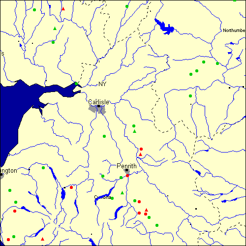
Stone Circles and Rows on Map Sheet NY
| NT |
||
| NX |
| NZ |
| SD |

Move the mouse over a point on the map to see the Stone Circle's name and map reference in the status bar.
| NT |
||
| NX |
| NZ |
| SD |
Move the mouse over a point on the map to see the Stone Circle's name and map reference in the status bar.
The Map sheet NY covers a 100 km2 area which includes the following stone circles and rows:
Blakeley Raise Stone Circle at map reference NY060140. www Broad Flat Stone Circle at map reference NY425445. Broomrigg group at map reference NY548467. Castlerigg Stone Circle at map reference NY291236. www Dacre Parish Stone Circle at map reference NY493277. East Steel Farm Stone Circle at map reference NY776610. Elvaplain Stone Circle at map reference NY176317. Gamelands Stone Circle at map reference NY640082. Glassonby Stone Circle at map reference NY575393. www Goatstones Stone Circle at map reference NY829748. Gretigate Stone Circle at map reference NY057036. Grey Croft Stone Circle at map reference NY034024. www Grey Yauds Stone Circle at map reference NY545487. Gunnerkeld Stone Circle at map reference NY568178. www Iron Hill group at map reference NY596147. www Kemp Howe Stone Circle at map reference NY567133. www Kirkhill Stone Circle at map reference NY140960. Kirkslight Rig group at map reference NY223885. Kopstone group at map reference NY496216. Lamplugh Stone Circle at map reference NY065177. Lochmaben Stane Stone Circle at map reference NY311660. Long Meg group at map reference NY571372. www Loupin` Stanes group at map reference NY257966. www Low Longrigg group at map reference NY172028. www Mayburgh Stone Circle at map reference NY519284. www Motherby Stone Circle at map reference NY419282. Ninestone Rigg Stone Circle at map reference NY518973. Nunwick Park Stone Circle at map reference NY885741. Oddendale Stone Circle at map reference NY593129. www Ridley Common Stone Circle at map reference NY778698. Simonburn Stone Circle at map reference NY802712. Studfold Stone Circle at map reference NY040224. Swarth Fell Stone Circle at map reference NY457192. White Hag Stone Circle at map reference NY607115. Whiteholm Rigg Stone Circle at map reference NY217827. Wilson Scar Stone Circle at map reference NY549182. Map sheet NY is also the likely location for the following stone circles and rows which have been destroyed: - Girdle Stanes Stone Row(s) at approximate map reference NY257966. This is an uncertain site according to Burl
- Chapel Flat Stone Circle at approximate map reference NY370500. - Eggleston Stone Circle at approximate map reference NY982252. Formerly marked as 'extant' on the last version of the Megalithic MapI'm afraid it no longer exists. It was broken up for road materials in the
nineteenth century. What is known of it suggests that it was of a type more
commonly found in Cumbria - a cairn circle - where a ring of stones surrounded
a cairn or burial mound, I think I might be able to track down a 18C engraving
if this might help
Steve Watson
- Herd Wood Stone Circle at approximate map reference NY410060. - Woodhead Stone Circle at approximate map reference NY210660. - Broad Field Stone Row(s) at approximate map reference NY425445. This is an uncertain site according to Burl
- Brougham Hall Stone Circle at approximate map reference NY520280. - Crosby Ravensworth Stone Row(s) at approximate map reference NY655115. - Shap Stone Row(s) at approximate map reference NY567133. - Grey Yauds Stone Row(s) at approximate map reference NY545487. This is an uncertain site according to Burl
- Lowther Woodhouse Stone Row(s) at approximate map reference NY525265. - Moor Divock Stone Row(s) at approximate map reference NY491227. - Newbiggin Stone Row(s) at approximate map reference NY471293. - Newton Reigny Stone Row(s) at approximate map reference NY475315. - Penhurrock Stone Row(s) at approximate map reference NY629104. This is an uncertain site according to Burl
- Carlatton Stone Row(s) at approximate map reference NY534510. These lost megalithic sites do not appear on the map above, as their locations are uncertain. Any information about these sites, particularly if you know they exist, would be very much appreciated.
Mail us with any information. The name and map reference of the megaliths appear in the status bar when the mouse pointer is placed over a point on the map above. In each map reference, the letters NY refer to the 100 km2 sheet shown above. The next three numbers are the distance across from the left edge (0 to 999)
and the final three numbers are the distance up from the bottom edge, (0 to 999). A point on the map in red has further details on another web site, a point in green does not Circles on the map represent stone circles, squares represent single or multiple stone rows or avenues, triangles represent group sites
with two or more megalithic sites close together.
 |
The list of stone circles and rows included in this resource is now available for browsing alphabetically. |
 |
Any stone circle or row indicated on the above map has further details given on a separate page here at the Megalith Map. Circles and rows indicated by a www tag, have links to websites elsewhere on the internet containing more text and/or images. Tell us about a stone circle or row not included on the above map by dropping us a line, and helping us to make this resource better for all who use it.
Go back to the map of the British Isles.
This information is brought to you by Andy and Alastair's Cheeseless ProductionsTM. This page published on 03/10/98 22:06:56.