Stone Circles and Rows on Map Sheet NX
| NS |
||
| NY |
|
| SC |

Move the mouse over a point on the map to see the Stone Circle's name and map reference in the status bar.
| NS |
||
|
| NY |
|
| SC |
Move the mouse over a point on the map to see the Stone Circle's name and map reference in the status bar.
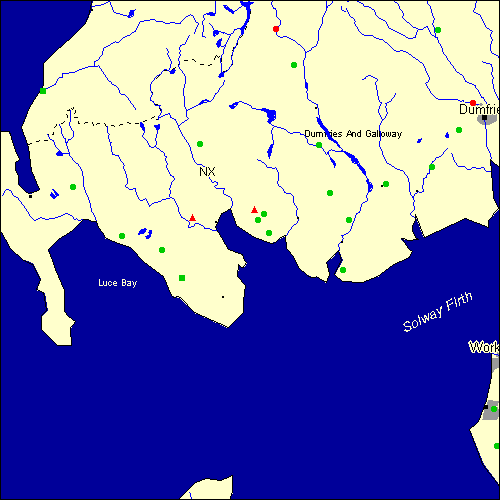
The Map sheet NX covers a 100 km2 area which includes the following stone circles and rows:
Ballantrae Stone Row(s) at map reference NX087818. Cauldside Burn Stone Circle at map reference NX529571. Claughreid Stone Circle at map reference NX517560. Drannandow Stone Circle at map reference NX401711. Drummore Stone Circle at map reference NX688459. Drumtroddan Stone Row(s) at map reference NX364443. Easthill Stone Circle at map reference NX919739. Egremont Stone Circle at map reference NX995107. Eldrig Loch Stone Circle at map reference NX324498. Ernespie Stone Circle at map reference NX774632. Glenquickan group at map reference NX509582. www Glentirrow Stone Circle at map reference NX146625. High Auchenlarie Stone Circle at map reference NX539534. Holm Of Daltallochan Stone Circle at map reference NX554942. www Kirkbog Stone Circle at map reference NX877939. Kirkgunzeon Stone Circle at map reference NX865666. Lairdmannoch Stone Circle at map reference NX662614. Le Wheles Stone Circle at map reference NX989180. Loch Roan Stone Circle at map reference NX640709. Park Of Tongland Stone Circle at map reference NX699560. Steeps Park Stone Circle at map reference NX245527. Stroangassel Stone Circle at map reference NX589869. Torhousekie group at map reference NX384565. www Twelve Apostles Stone Circle at map reference NX947794. www Map sheet NX is also the likely location for the following stone circles and rows which have been destroyed: - Torhousekie West Stone Row(s) at approximate map reference NX381565. This is an uncertain site according to Burl
- Little Balmae Stone Circle at approximate map reference NX680440. - Laggangarn Stone Circle at approximate map reference NX220710. - Haggstone Moor Stone Circle at approximate map reference NX060720. - Greystone Park Stone Circle at approximate map reference NX980760. - Gray Stanes Stone Circle at approximate map reference NX090820. These lost megalithic sites do not appear on the map above, as their locations are uncertain. Any information about these sites, particularly if you know they exist, would be very much appreciated.
Mail us with any information. The name and map reference of the megaliths appear in the status bar when the mouse pointer is placed over a point on the map above. In each map reference, the letters NX refer to the 100 km2 sheet shown above. The next three numbers are the distance across from the left edge (0 to 999)
and the final three numbers are the distance up from the bottom edge, (0 to 999). A point on the map in red has further details on another web site, a point in green does not Circles on the map represent stone circles, squares represent single or multiple stone rows or avenues, triangles represent group sites
with two or more megalithic sites close together.
 |
The list of stone circles and rows included in this resource is now available for browsing alphabetically. |
 |
Any stone circle or row indicated on the above map has further details given on a separate page here at the Megalith Map. Circles and rows indicated by a www tag, have links to websites elsewhere on the internet containing more text and/or images. Tell us about a stone circle or row not included on the above map by dropping us a line, and helping us to make this resource better for all who use it.
Go back to the map of the British Isles.
This information is brought to you by Andy and Alastair's Cheeseless ProductionsTM. This page published on 03/10/98 22:06:29.