Stone Circles and Rows on Map Sheet SW
| SV |
| SX |

Move the mouse over a point on the map to see the Stone Circle's name and map reference in the status bar.
| SV |
| SX |
Move the mouse over a point on the map to see the Stone Circle's name and map reference in the status bar.
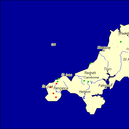
The Map sheet SW covers a 100 km2 area which includes the following stone circles and rows:
Boscawen-Un Stone Circle at map reference SW412274. www Boskednan Stone Circle at map reference SW436351. www Hr Carwynnen Stone Circle at map reference SW652372. Merry Maidens Stone Circle at map reference SW433245. www New Downs Stone Circle at map reference SW701507. Nine Maidens Stone Row(s) at map reference SW936675. Treen Common Stone Circle at map reference SW444366. Tregeseal group at map reference SW389325. www Treveglos, Zennor Stone Row(s) at map reference SW453388. Wendron Stone Circle at map reference SW683365. Map sheet SW is also the likely location for the following stone circles and rows which have been destroyed: - Whitesand Bay Stone Circle at approximate map reference SW350260. - Trevello Stone Circle at approximate map reference SW449263. Formerly marked as 'extant' this circle has been destroyed, more information please
- Tregeseal W Stone Circle at approximate map reference SW386323. - Tregeseal C Stone Circle at approximate map reference SW385322. Formerly marked as 'extant' this circle has been destroyed, more information please
- Treen Stone Circle at approximate map reference SW397222. Formerly marked as 'extant' this circle has been destroyed, more information please
- Tredinnick Stone Circle at approximate map reference SW442349. Formerly marked as 'extant' this circle has been destroyed, more information please
- Rosemergy Stone Circle at approximate map reference SW417363. Formerly marked as extant - removed on advice
- Bosiliack Stone Circle at approximate map reference SW440320. These lost megalithic sites do not appear on the map above, as their locations are uncertain. Any information about these sites, particularly if you know they exist, would be very much appreciated.
Mail us with any information. The name and map reference of the megaliths appear in the status bar when the mouse pointer is placed over a point on the map above. In each map reference, the letters SW refer to the 100 km2 sheet shown above. The next three numbers are the distance across from the left edge (0 to 999)
and the final three numbers are the distance up from the bottom edge, (0 to 999). A point on the map in red has further details on another web site, a point in green does not Circles on the map represent stone circles, squares represent single or multiple stone rows or avenues, triangles represent group sites
with two or more megalithic sites close together.
 |
The list of stone circles and rows included in this resource is now available for browsing alphabetically. |
 |
Any stone circle or row indicated on the above map has further details given on a separate page here at the Megalith Map. Circles and rows indicated by a www tag, have links to websites elsewhere on the internet containing more text and/or images. Tell us about a stone circle or row not included on the above map by dropping us a line, and helping us to make this resource better for all who use it.
Go back to the map of the British Isles.
This information is brought to you by Andy and Alastair's Cheeseless ProductionsTM. This page published on 03/10/98 22:08:54.