Stone Circles and Rows on Map Sheet SX
| SS |
||
| SW |
| SY |

Move the mouse over a point on the map to see the Stone Circle's name and map reference in the status bar.
| SS |
||
| SW |
| SY |
Move the mouse over a point on the map to see the Stone Circle's name and map reference in the status bar.
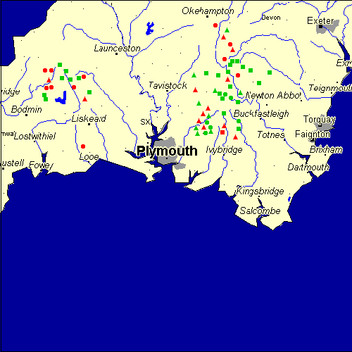
The Map sheet SX covers a 100 km2 area which includes the following stone circles and rows:
Assacombe Stone Row(s) at map reference SX660826. Black Tor SW Stone Row(s) at map reference SX677634. Brockhill Ford Stone Circle at map reference SX678656. Burford Down group at map reference SX667612. www Buttern Hill Stone Row(s) at map reference SX169815. Carneglos Stone Row(s) at map reference SX198773. Challacombe Stone Row(s) at map reference SX689809. Cholwichtown Stone Circle at map reference SX584622. Collard Tor group at map reference SX559621. Colvannick Tor Stone Row(s) at map reference SX128718. Conies Down Stone Row(s) at map reference SX586791. Cosdon group at map reference SX643916. Craddock Moor group at map reference SX239720. www Down Ridge Stone Circle at map reference SX655721. Down Tor group at map reference SX590694. www Drizzlecombe group at map reference SX591672. Duloe Stone Circle at map reference SX235583. www East Moor Stone Row(s) at map reference SX223778. Fernacre Stone Circle at map reference SX144799. www Goodaver Stone Circle at map reference SX208751. www Grey Wethers Stone Circle at map reference SX638832. www Holne Moor Stone Row(s) at map reference SX675709. Joan Ford Newtake Stone Row(s) at map reference SX632720. Lakehead group at map reference SX645776. www Langstone Downs Stone Row(s) at map reference SX253737. Langstone Moor group at map reference SX550788. Laughter Tor Stone Row(s) at map reference SX653753. Leaze group at map reference SX137773. www Leskernick Hill Stone Row(s) at map reference SX187798. Merrivale group at map reference SX553746. www Natsworthy Stone Row(s) at map reference SX712800. Nine Stones (Bodmin) Stone Circle at map reference SX236781. www Nine Stones (Dartmoor) Stone Circle at map reference SX612928. www Penn Beacon group at map reference SX598627. Ringhill Stone Row(s) at map reference SX647795. Ringmoor group at map reference SX563658. www Scorhill Stone Circle at map reference SX654873. www Sharpitor group at map reference SX564708. Shaugh Moor group at map reference SX555638. Shell Top Stone Circle at map reference SX598638. Sherberton Stone Circle at map reference SX639732. Shovel Down group at map reference SX660860. www Soussons Common Stone Circle at map reference SX675786. www Stall Moor - Green Hill Stone Row(s) at map reference SX636678. Stall Moor group at map reference SX635644. www Stalldown Barrow Stone Row(s) at map reference SX632623. www Stannon Stone Circle at map reference SX126800. www Stannon Stone Row(s) at map reference SX654815. Stripple Stones Stone Circle at map reference SX144752. www Tolborough Tor Stone Row(s) at map reference SX175778. Top Tor Stone Row(s) at map reference SX735764. Tor Royal Newtake Stone Row(s) at map reference SX623734. Trehudreth Downs Stone Row(s) at map reference SX124729. Trendlebere Down Stone Row(s) at map reference SX766793. Trippet Stones Stone Circle at map reference SX131750. www Trowlesworthy Warren group at map reference SX577640. www Two Bridges group at map reference SX610744. Watern Hill Stone Row(s) at map reference SX673825. White Moor Down group at map reference SX634896. www White Tor Stone Row(s) at map reference SX620785. Willing Walls Warren Stone Circle at map reference SX587652. Yar Tor group at map reference SX682738. Yellowmead group at map reference SX575678. www Map sheet SX is also the likely location for the following stone circles and rows which have been destroyed: - Soussons Down Stone Row(s) at approximate map reference SX676799. - Sherril Down Stone Row(s) at approximate map reference SX687734. - Sharpitor NW Stone Row(s) at approximate map reference SX559708. - Sharpitor E Stone Row(s) at approximate map reference SX561709. - Ramsley Stone Row(s) at approximate map reference SX651931. - Penn Beacon SE Stone Row(s) at approximate map reference SX599625. - Oke Tor Stone Row(s) at approximate map reference SX605895. - Longstone Farm Stone Row(s) at approximate map reference SX362803. - Cocks Tor Stone Row(s) at approximate map reference SX530760. - Cholwich Town Waste Stone Row(s) at approximate map reference SX583623. These lost megalithic sites do not appear on the map above, as their locations are uncertain. Any information about these sites, particularly if you know they exist, would be very much appreciated.
Mail us with any information. The name and map reference of the megaliths appear in the status bar when the mouse pointer is placed over a point on the map above. In each map reference, the letters SX refer to the 100 km2 sheet shown above. The next three numbers are the distance across from the left edge (0 to 999)
and the final three numbers are the distance up from the bottom edge, (0 to 999). A point on the map in red has further details on another web site, a point in green does not Circles on the map represent stone circles, squares represent single or multiple stone rows or avenues, triangles represent group sites
with two or more megalithic sites close together.
 |
The list of stone circles and rows included in this resource is now available for browsing alphabetically. |
 |
Any stone circle or row indicated on the above map has further details given on a separate page here at the Megalith Map. Circles and rows indicated by a www tag, have links to websites elsewhere on the internet containing more text and/or images. Tell us about a stone circle or row not included on the above map by dropping us a line, and helping us to make this resource better for all who use it.
Go back to the map of the British Isles.
This information is brought to you by Andy and Alastair's Cheeseless ProductionsTM. This page published on 03/10/98 22:09:08.